Datei:SyltSat.jpg
Heh di Vör_Aanseesch es 445 Pixelle breed × 600 Pixelle huh jruuß. Ander Oplühsunge: 178 Pixelle breed × 240 Pixelle huh · 356 Pixelle breed × 480 Pixelle huh · 668 Pixelle breed × 900 Pixelle huh.
Ojinaal-Dattei (668 Pixelle breed × 900 Pixelle huh, de Datei hät 40 KB, de MIME-Zood es: image/jpeg)
Beschrievungstex un Zosammefassung
| Zosammefassung |
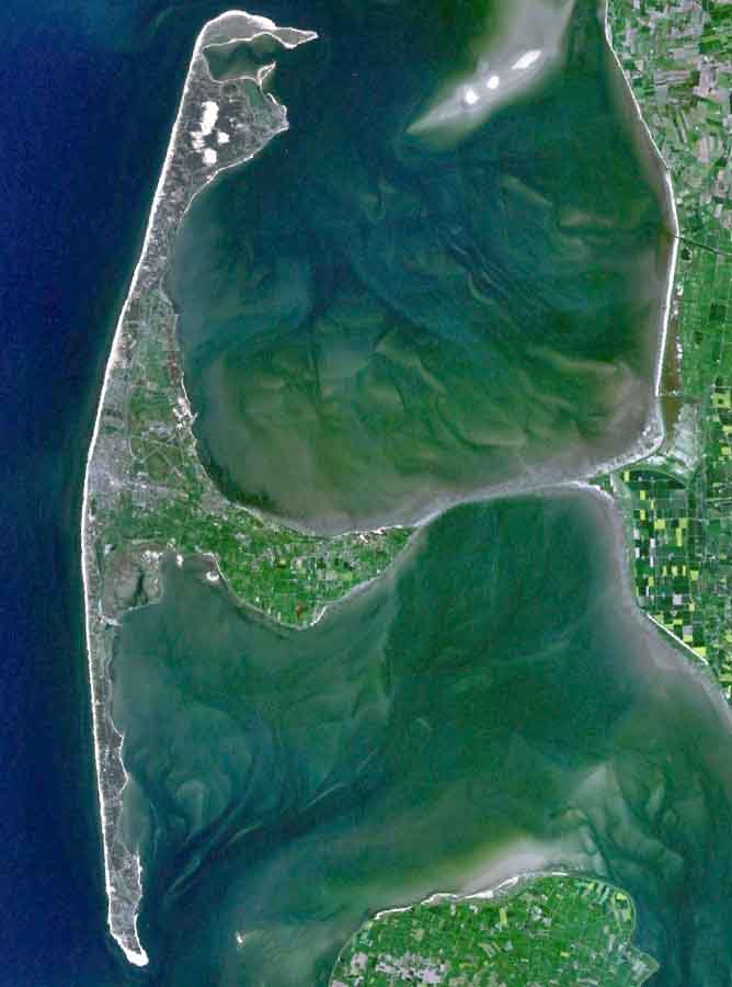
English: The Island of Sylt in Northern Germany from the South. Satellite view. |
| Et Dattum | 24. Aprel 2005 (Hochladedatum) |
| Quell | Satellite imagery taken from NASA World Wind software (by screenshot) |
| Dä Urhävver | NASA |
Lizänz
| Diese Datei ist gemeinfrei (Public Domain), da es sich um einen Screenshot der NASA-Software World Wind handelt, in der ein gemeinfreier Datensatz wie Blue Marble, MODIS, Landsat, SRTM, USGS oder GLOBE verwendet wird.
|
 |
| Annotations | This image is annotated: View the annotations at Commons |
De Väsjohne vun dä Dattei
Di domohlije Version kriß De jezeich övver dä Link op em Dattum.
| Väsjohn vom | Minni-Belldsche | Pixelle Breed×Hühte (Dateiömfang) | Metmaacher | Aanmärkong | |
|---|---|---|---|---|---|
| Von jetz | 21:39, 4. Auj 2006 | | 668 × 900 (40 KB) | Ollio | original work of NASA - public domain picture made brigther by O. Lippuner (User --~~~~), without changing public domain status |
| 16:01, 24. Apr 2005 |  | 668 × 900 (350 KB) | SeballaOne~commonswiki | The Island of Sylt in Northern Germany from the South. Created with World Wind {{PD-USGov-NASA}} Category:Islands Category:Satellite photos |
Jebruch
Heh kütt di Sigg, di op heh di Dattei lengke deiht:
Jemeinsam jebruch Dateie
Heh di ander Wikis bruche di Dattei:
- Der Jebruch op af.wikipedia.org
- Der Jebruch op ar.wikipedia.org
- Der Jebruch op br.wikipedia.org
- Der Jebruch op ca.wikipedia.org
- Der Jebruch op da.wikipedia.org
- Der Jebruch op de.wikipedia.org
- Der Jebruch op en.wikipedia.org
- Der Jebruch op eo.wikipedia.org
- Der Jebruch op es.wikipedia.org
- Der Jebruch op fa.wikipedia.org
- Der Jebruch op frr.wikipedia.org
- Der Jebruch op fr.wikipedia.org
- Der Jebruch op fy.wikipedia.org
- Der Jebruch op is.wikipedia.org
- Der Jebruch op it.wikipedia.org
- Der Jebruch op ko.wikipedia.org
- Der Jebruch op mk.wikipedia.org
- Der Jebruch op nds.wikipedia.org
- Der Jebruch op nn.wikipedia.org
- Der Jebruch op no.wikipedia.org
- Der Jebruch op pnb.wikipedia.org
- Der Jebruch op pt.wikipedia.org
- Der Jebruch op stq.wikipedia.org
- Der Jebruch op sv.wikipedia.org
- Der Jebruch op xmf.wikipedia.org
- Der Jebruch op zh.wikipedia.org