Datei:Carte des villes américaines.svg

Der Ömvang vun heh däm PNG-Minnibeldsche vun dä Ojinahl SVG-Datteij es: 800 Pixelle breed × 522 Pixelle huh. Ander Oplühsunge: 320 Pixelle breed × 209 Pixelle huh · 640 Pixelle breed × 418 Pixelle huh · 1024 Pixelle breed × 669 Pixelle huh · 1280 Pixelle breed × 836 Pixelle huh · 2560 Pixelle breed × 1672 Pixelle huh · 908 Pixelle breed × 593 Pixelle huh.
Ojinaal-Dattei (SVG-Datei, de Basis es 908 Pixelle breed × 593 Pixelle huh, dä Dateiömfang es 494 KB)
W3C-validity not checked.
| Zosammefassung |
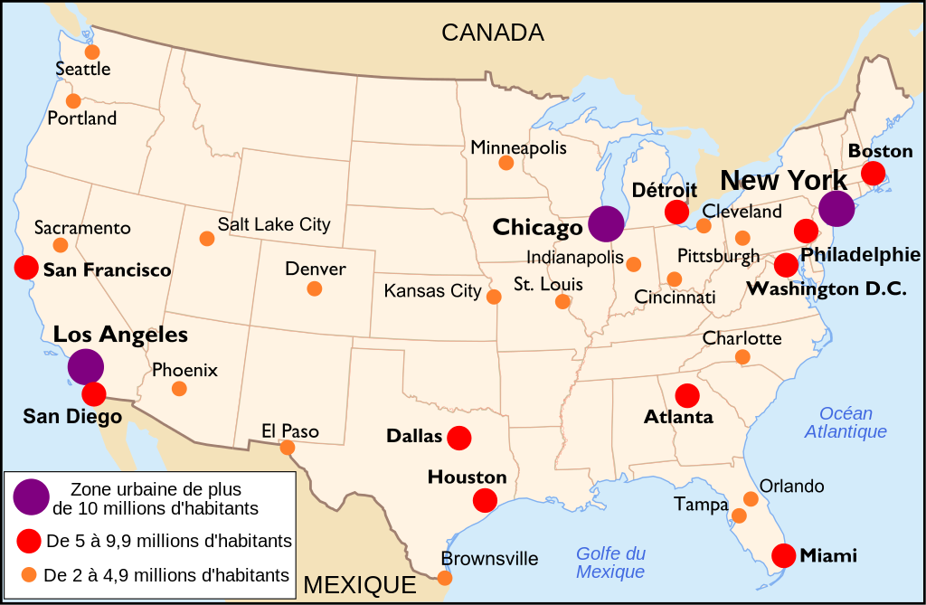
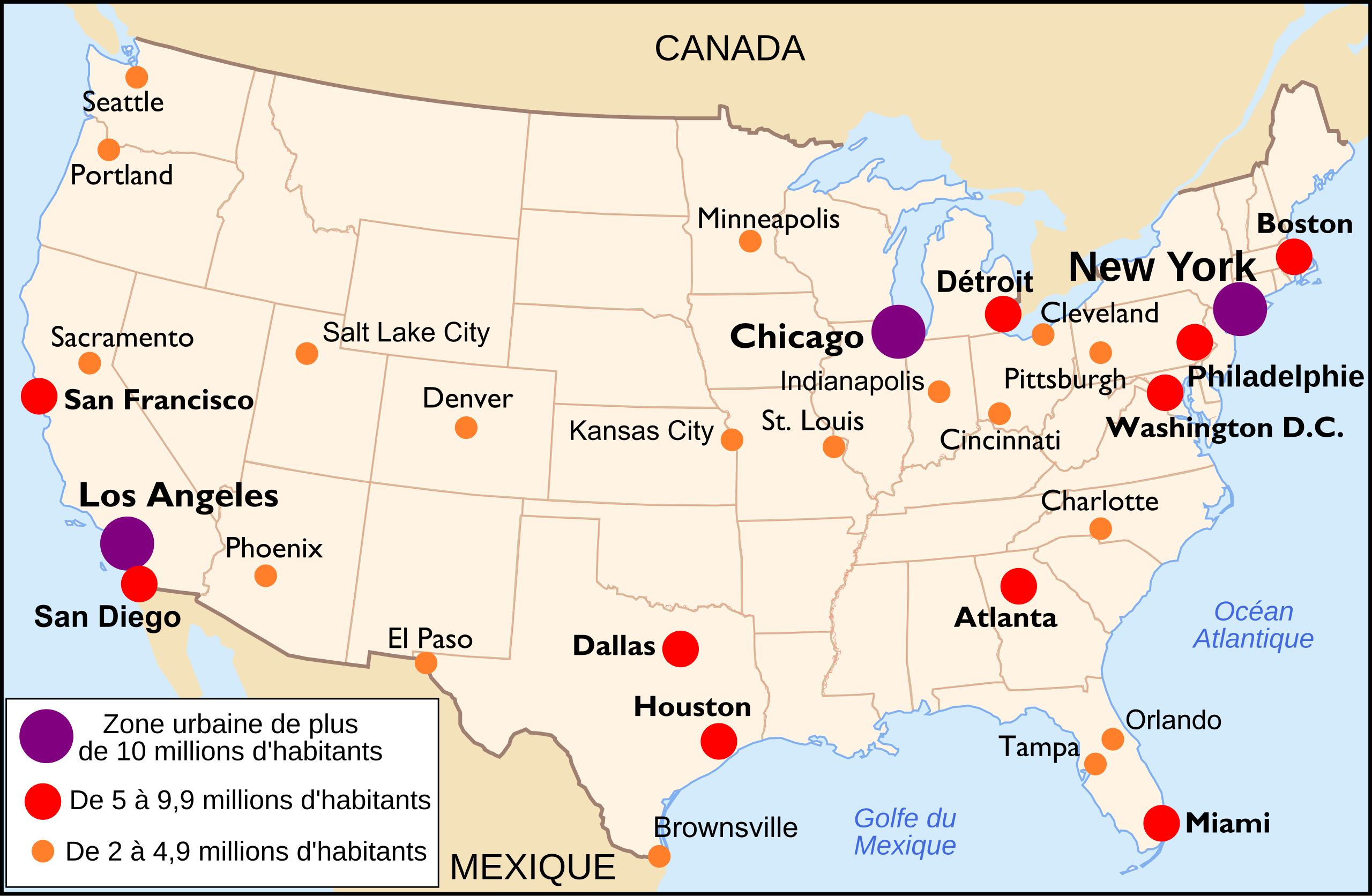
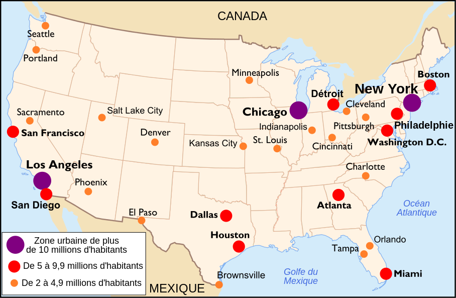
Français : Carte des villes américaines (Français) Español: Mapa de las principales áreas urbanas de Estados Unidos (Francés). English: Main US towns map (French) |
||||||||
| Et Dattum | |||||||||
| Quell | http://commons.wikimedia.org/wiki/Image:Mapa_ciudades_USA.svg by Mortadelo2005 | ||||||||
| Dä Urhävver | historicair 20:27, 13 November 2006 (UTC) | ||||||||
| Zohshtemmung (Di Dattei och anderswo bruche) |
Esh han et Urhävverääsch vun däm Wärk, un maachen dat Wärk öffentlesch unger dä Lizänze heh:
He di Dattei es ze han under dä Bedengonge vun de Creative Commons ier Lizänze:
„met Namensnännong, un Wiggerjävve onger derselleve Bedengunge Version 2.5, alljemein“ un „met Namensnännong, un Wiggerjävve onger derselleve Bedengunge Version 2.0, alljemein“ un „met Namensnännong, un Wiggerjävve onger derselleve Bedengunge Version 1.0, alljemein“.
Do kanns Der en Lizänz ußsöhke. |
||||||||
| Ander Väsjohne |
Derivative works of this file: |

De Väsjohne vun dä Dattei
Di domohlije Version kriß De jezeich övver dä Link op em Dattum.
| Väsjohn vom | Minni-Belldsche | Pixelle Breed×Hühte (Dateiömfang) | Metmaacher | Aanmärkong | |
|---|---|---|---|---|---|
| Von jetz | 16:16, 30. Okt 2010 | | 908 × 593 (494 KB) | Tachymètre | changed the oceans name's color to #4169E1, replaced the water's blue frame in the center of the map |
| 20:33, 28. Feb 2009 |  | 908 × 593 (491 KB) | Nakor | Update with data from http://www.populationdata.net/index2.php?option=pays&pid=64&nom=etats_unis | |
| 22:32, 13. Nov 2006 |  | 908 × 593 (454 KB) | Historicair | ||
| 22:27, 13. Nov 2006 |  | 908 × 593 (454 KB) | Historicair | {{Information |Description={{fr}}La bataille de Koh Chang (17 janvier 1941) {{en}}The Koh Chang battle (January 17th, 1941) |Source={{fr}}Carte des villes américaines {{es}}Mapa de las principales áreas urbanas de Estados Unidos. {{en}}Main US towns map |
Jebruch
Nix Lengk op heh di Dattei.
Jemeinsam jebruch Dateie
Heh di ander Wikis bruche di Dattei:
- Der Jebruch op eu.wikipedia.org
- Der Jebruch op fr.wikipedia.org
- Der Jebruch op ht.wikipedia.org
- Der Jebruch op hu.wikipedia.org
- Der Jebruch op incubator.wikimedia.org
- Der Jebruch op mg.wikipedia.org
- Der Jebruch op pcd.wikipedia.org
- Der Jebruch op pt.wikipedia.org